Ningbo Lion Mountain — Transforming Topography into Community
April 7th, 2021
Ningbo, China

LOCATION
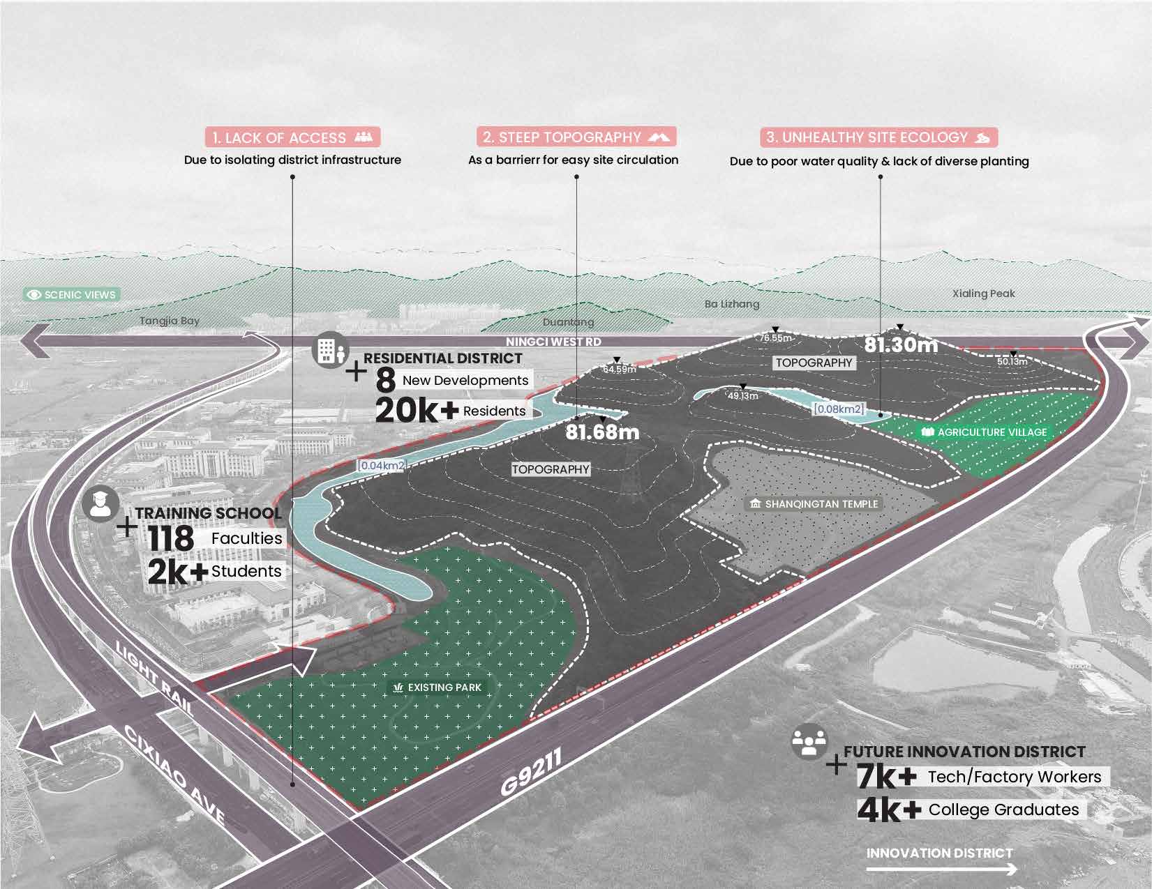
Located between central Ningbo, China and nearby scenic landscapes, Ningbo Lion Mountain is poised to provide vast ecological and recreation benefits by linking local open spaces. Rising 82 meters above agricultural villages within a developing mixed-use district, the site has remained largely inaccessible. The steep topography and lack of paths has left it undeveloped but also under-utilized.
Ningbo Lion Mountain is at the heart of the 2019 Jiangbei District masterplan that envisions new recreational linkages which take advantage of the site topography. The design proposes strategic access points and a comprehensive network of various paths and programs to connect the park to its urban interface. This framework prioritizes ecological regeneration and innovative programming to support climate resilience and community health.


 CONTEXT
Ningbo Lion Mountain is located within the northwest Jiangbei District of Ningbo, China and stands 80 meters tall within a landscape rich in topography and scenic views. A gateway to neighboring Kaolaoshan Scenic Area, Lion Mountain is part of a network of prominent regional open space surrounding the city core. As a link in this chain of city parks, Lion Mountain is poised to play an important public open space role in the developing district of Jiangbei.
Locally, Lion Mountain is bordered by an existing educational institution, a planned residential community and a new innovation district that is currently occupied by light industry. On site, the mountain rises above agricultural villages and a canal that has been stressed by urbanization.

CONCEPT
Isolated by highways, waterways and steep topography, Lion Mountain has largely been left inaccessible with minimal ecologunction. However, the park’s unique location and under-utilized open space resources give it the potential to knit together both parks and disparate parts of Jiangbei District.
The new masterplan for Lion Mountain creates a heart for the community by enhancing this key open space with environmental regeneration and recreational opportunities. The design focuses on improving site accessibility and programs while prioritizing the ecology on site.
To achieve this goal, the development of the masterplan was led by landscape architects acting as a liaison between government agencies and local communities, with input from hydrologists.
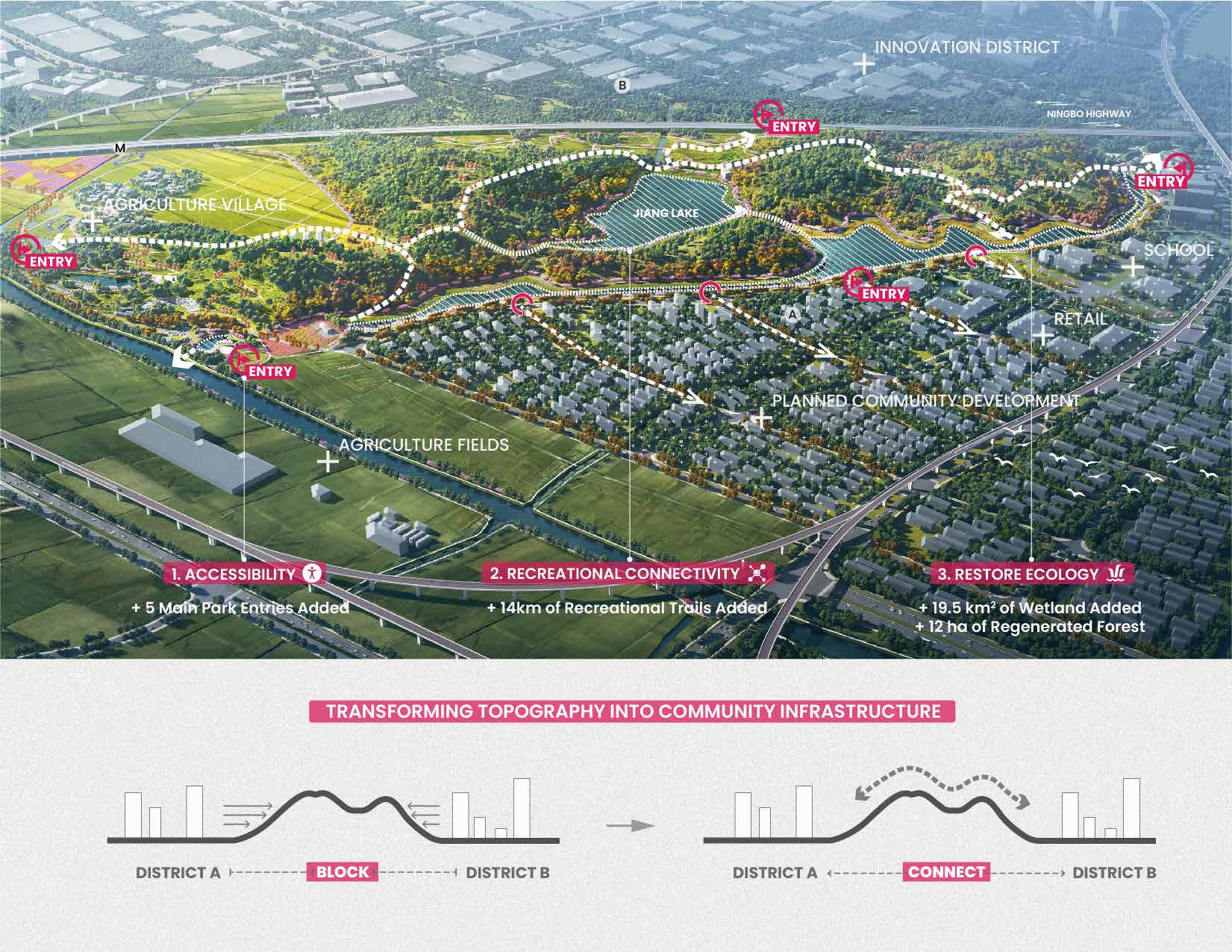
URBAN INTERFACE LINKAGE
The primary goal of the masterplan is to address accessibility challenges through strategic urban interface links. Green street corridors connect the canal waterfront to nearby residences, retail center and school campus. Entries located at the northern and southern ends of the canal provide parking for visitors coming from the wider area, as well as playgrounds, cafe kiosks, and activity lawns. These entries into the site are designed to serve their local context with programs for neighborhood user groups and make the park accessible to visitors from the region. The retail center entry welcomes visitors along the western shore and draws shoppers into the park to enjoy the vibrant waterfront and views of the verdant mountain.


RECREATIONAL PROGRAMS
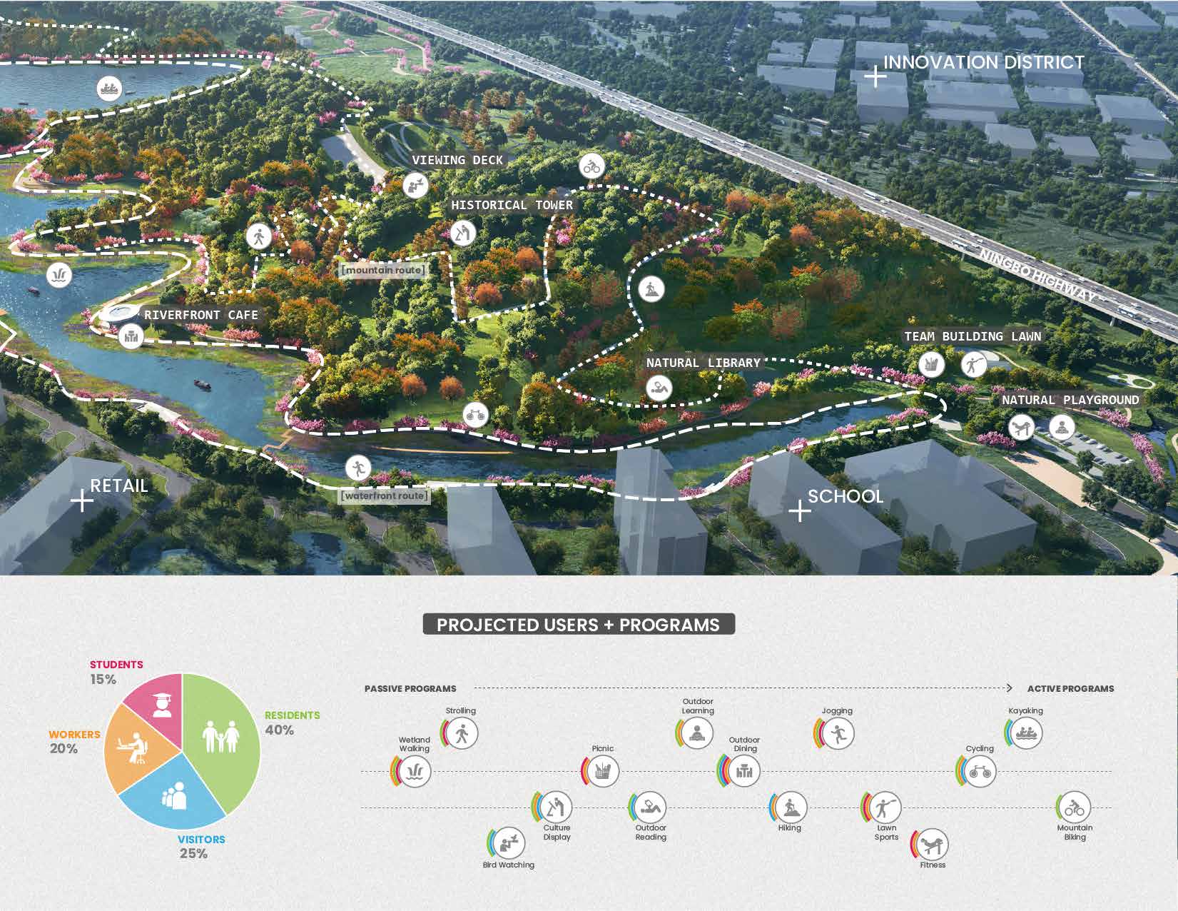
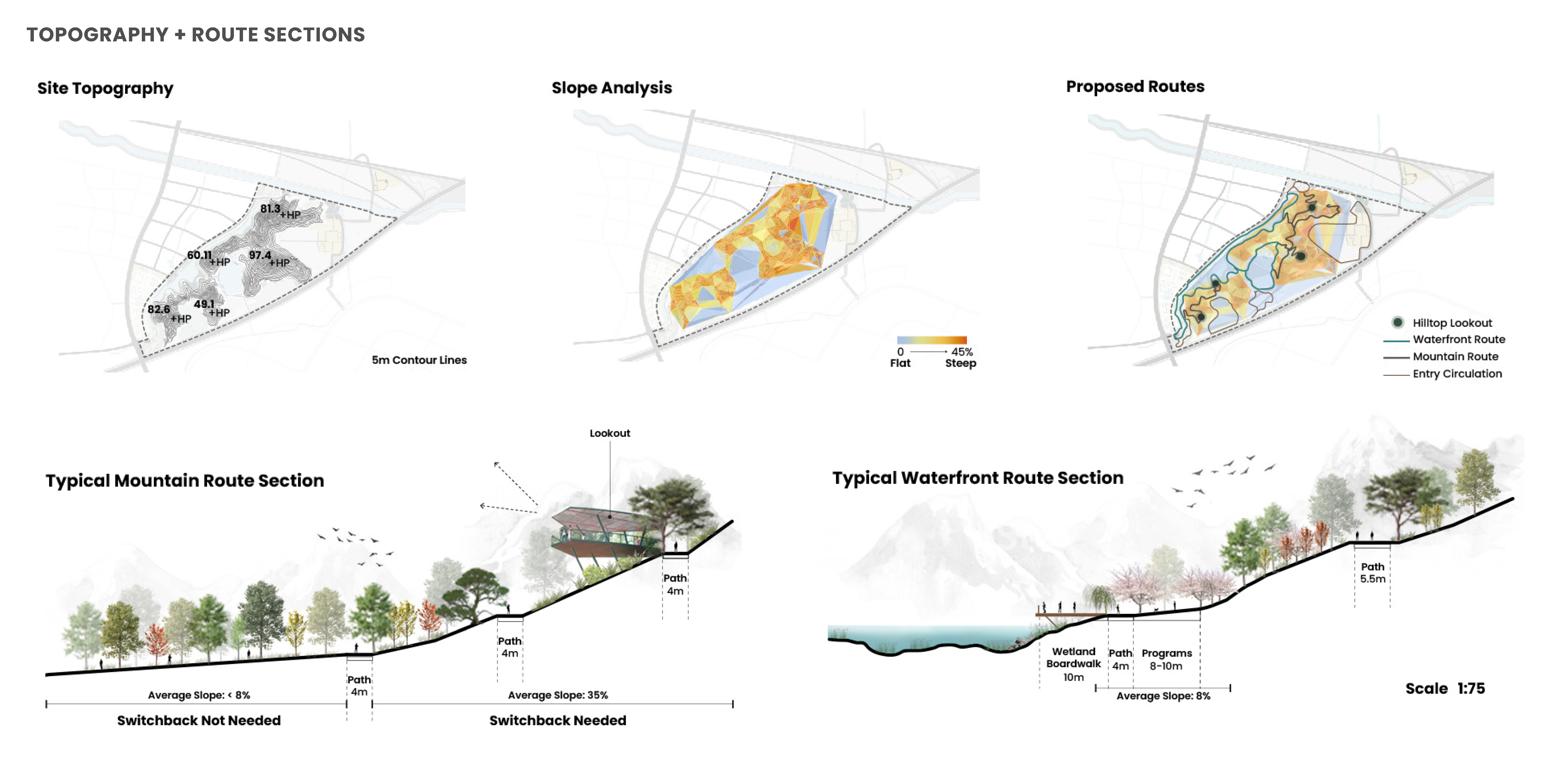
Adding 14 kilometers of trails creates a comprehensive network which takes advantage of the topography on site and allows a wide variety of experiences and activities.
Programmatic nodes along the extensive waterfront are designed not only for the use of the community and visitors, but to enhance the site’s existing natural resources. A series of waterfront routes weave along the canal and Jiang Lake to allow for wildlife viewing and education, or leisurely strolls. Programmatic nodes along these routes provide space for gathering, events, and outdoor play. Transforming the canal into a community corridor, the waterfront features an activity lawn, event space, bike rental stations and branching pathways that link into the mountain trails above.
Embracing the site topography, hiking trails climb steep terrain alongside a mountain biking route that challenges adventurous visitors. From the highest point, lookouts create a visual connection from the park to the surrounding urban district, with nearby agricultural villages in the middle ground.

ECOLOGICAL ENHANCEMENT
Along with recreational value, the site lies between two major regional parks, it has the potential to support local wildlife and broader ecological functions.
The plan regrades the canal to create 19.5 square kilometers of wetland that provides habitat and cleans runoff. Waterfront pathways bring people into these revitalized shorelines with a series of boardwalks, wetland decks and educational signage. The park acts as an outdoor classroom for people of all ages, while supporting the hydrologic function of the region.
Strategic reforesting techniques diversify existing tree species and understory planting to improve the forest’s biodiversity and habitat value. Interventions alongside new paths will result in 12 hectares of regenerated forest habitat.
Lion Mountain’s masterplan proposes a connected regional park that enhances the environment and the lives of its neighbors through targeted interventions which showcase the beauty of the place and provide spaces to enjoy it.


Project portfolio here